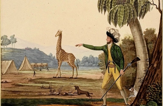
On loan from the Bibliothèque Nationale in Paris, the 3x2m, 223-year-old map has never been on public display and when the current exhibition closes it will apparently be packed away again for 180 years, one year for every day of exposure.
The phenomenal map, which records Le Vaillant’s extensive travels around South Africa from 1781 to 1784, is lavishly illustrated with the indigenous people he met, 66 different species of animals, birds and plants, and about 600 place names.
Looking at the map, one can imagine the king, one of the most watched people in the kingdom, escaping to his attic in Versailles to go on a vicarious journey with his index finger over Mr Badenhorst’s farm, pausing at Camp des Puces (the Camp of Fleas), and hastily traversing the Pays plein de Lions et de Tigres (Country full of Lions and Leopards).
The exhibition in a specially created room at the Iziko South African Museum includes original works by Le Vaillant, watercolours from the Parliament collection, magnificent bird illustrations and precious elephant-folio versions of his bird books from the Brenthurst collection. A man taking a leak can be spotted in one of the illustrations of his journey.
Hopefully, this exhibition will go a long way towards restoring Le Vaillant’s reputation and, as Glenn puts it, countering the unfortunate “double and mutually reinforcing cultural amnesia produced by figures in cultural wars” who wish us to believe there was “only one mode of colonial, Africanist discourse” in order “to present their own thoroughly modern virtue”.
Iziko South African Museum, Cape Town, until May 26
Full story in Mail & Guardian The man who put us on the map | Arts and Culture | Art and Design | Mail & Guardian.
Iziko Summer School Public Discussion: Tuesday 12 February, 18h00 – 19h30, T H Barry Lecture Theatre, Iziko SA Museum, Free.


